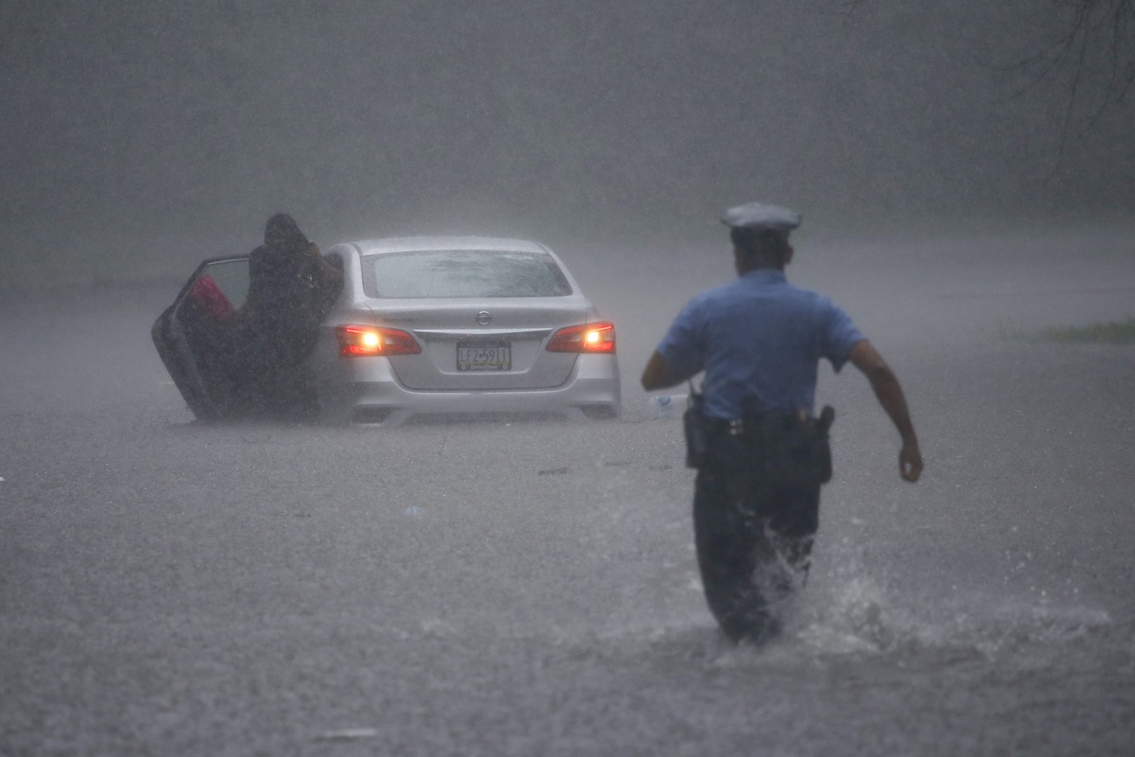
A Philadelphia police officer rushes to help a stranded motorist during Tropical Storm Isaias, Tuesday, Aug. 4, 2020, in Philadelphia. The storm spawned tornadoes and dumped rain during an inland march up the U.S. East Coast after making landfall as a hurricane along the North Carolina coast.
Hannah Chinn is PlanPhilly’s intern. She loves community storytelling, neighborhood equity, and public transit in all its forms. In the past, she’s written for NBC10, Willamette Week, Generocity, and the Philadelphia Inquirer. She lives in West Philly.
Joe Hernandez covers South Jersey for WHYY.
He previously worked at WNYC, as a producer on the local news desk and at The Takeaway, WNYC and PRI's morning drive show. His work has appeared on NPR, the Columbia Journalism Review, and NJ Spotlight.
A lifelong resident of South Seaside Park, Justin Auciello is a surfer, urban planner, journalist and traveler.
He prefers life in boardshorts and bare feet and aims to live the “endless summer,” which he somewhat accomplishes by spending time in Puerto Rico each winter, where he lives with the family of his lovely wife, Andreica, and surfs the northwestern coast of the Isla del Encanto.
But most of all, Justin’s insatiable drive is to keep people informed, whether it is covering a breaking news event on Jersey Shore Hurricane News – a two-way news outlet covering news, traffic and weather that he founded in August 2011 – or simply educating children about rip current safety during a lazy day on the beach.
Zoë Read is a Delaware reporter for WHYY News.
She received her Bachelor’s in English from the University of Delaware in 2011. While at the university, Read was the managing editor for the features section for the student newspaper, The Review.
She received her Master’s in Journalism from Columbia University in 2012. While at the university, Read wrote a 6,000 word thesis on HIV/AIDS in Harlem. An excerpt of the piece was later published on theatlantic.com.
Read most recently worked for the Capital newspaper in Annapolis, where she covered Anne Arundel County news. While at the paper, she won awards from the MDDC Association for her work in arts & culture, health, environmental and public service journalism.
Read’s freelance work also has been featured in the Kansas City Star, the Detroit News and the online version of The Atlantic.
Matt Slocum / AP Photo
A Philadelphia police officer rushes to help a stranded motorist during Tropical Storm Isaias, Tuesday, Aug. 4, 2020, in Philadelphia. The storm spawned tornadoes and dumped rain during an inland march up the U.S. East Coast after making landfall as a hurricane along the North Carolina coast.
Tropical Storm Isaias continued its travels along the East Coast Tuesday after crashing onto shore overnight, bringing widespread flooding, road closures and power outages across the Philadelphia region.
The National Weather Service reported that as of 1:30 p.m. Tuesday “widespread amounts “ of rain had already fallen — “4 to 6 inches with as much as 8 inches … and heavy rain is lifting to the north. Widespread flash flooding is occurring. The greatest totals are near and west of the I-95 corridor.”
Areas of flash flooding were expected, especially in urbanized and flood-prone areas, the Weather Service said. A Flash Flood Watch is in effect until midnight Tuesday.
PECO reported more than 1,800 power outages, affecting about 305 customers in the Philadelphia region, while PPL reported about 36,000 customers without power, primarily in Berks, Bucks, Lehigh and Lancaster counties. Delmarva Power reported 1,555 active outages across Delaware and parts of Maryland, affecting about 80,000 customers. New Jersey’s largest electric utilities — PSE&G, JCP&L, and Atlantic City Electric — reported more than 240,000 customers without power as of 11:45 a.m. By 2:45 p.m., PSE&G alone was reporting 5,804 outages affecting more than 430,000 customers.
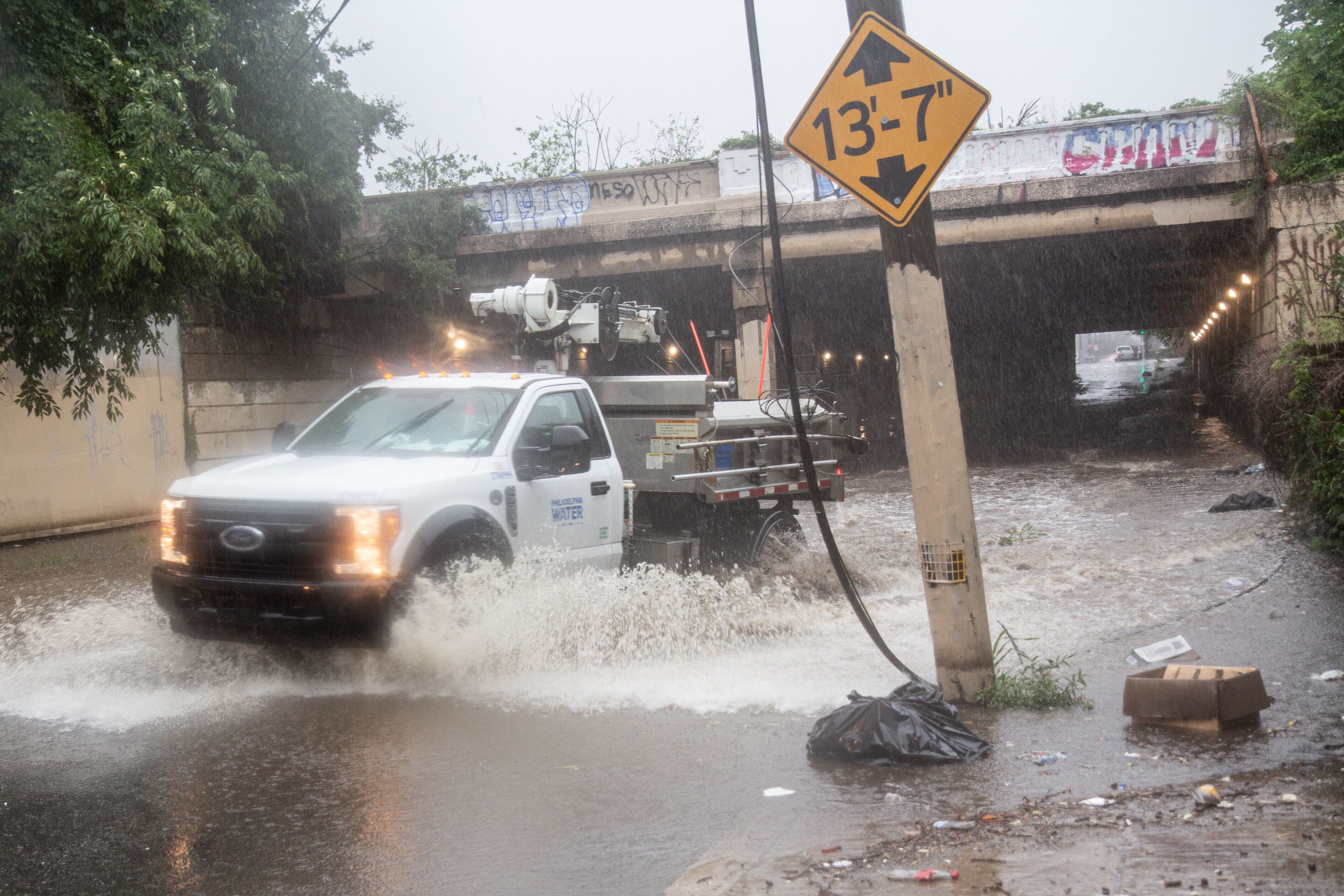
Kimberly Paynter / WHYY
A Philadelphia Water Department Vehicle closes down flooded Tulip and Lehigh streets during Tropical Storm Isaias in Philadelphia.
Weather watchers spotted a number of what appeared to be tornadoes across the Jersey Shore.
One circular cloud was spotted in Marmora, Cape May County, near Ocean City.
Marmora resident Rich Devine said his home lost power Tuesday morning amid high winds.
“The winds came in very big gusts, the trees were bending in every direction and then began to snap,” Devine said. “It was rather frightening. We had a concern that something would come into the house but nothing did.”
Devine said the gusts also downed several trees on his property.
In the Philadelphia suburbs, flooding caused intermittent road closures and stranded vehicles. In Bucks County, officials said a pregnant woman was rescued from her car in New Britain Township after her vehicle became stuck in high waters.
High winds tore across the Doylestown Hospital campus Tuesday afternoon, overturning vehicles in the parking lot and partially ripping the roof off the Children’s Village day care center there.
Doylestown Health spokesperson Ron Watson told WHYY that the staff was “still assessing [the] situation,” but that despite widespread campus damage, there were no serious injuries.
“As a result of the heroic efforts of the Children’s Village staff, hospital Associates and community first responders, all children and teachers were moved to safety in the radiation vault on the first floor of the Cancer Institute in the Pavilion. They were later transported to Lenape Middle School to be reunited with their families. Four children were treated for minor injuries and released,” Watson said in an email to WHYY.
The infusion center and lobby of the Cancer Institute at the Doylestown Health campus experienced damage, Watson said, as did the roof and windows of the pavilion where physician offices are located. A half-dozen vehicles or more were damaged in the parking lots on campus, he said.
Earlier in the day, some residents and businesses in Conshohocken, Montgomery County, were asked to evacuate due to flash flooding.
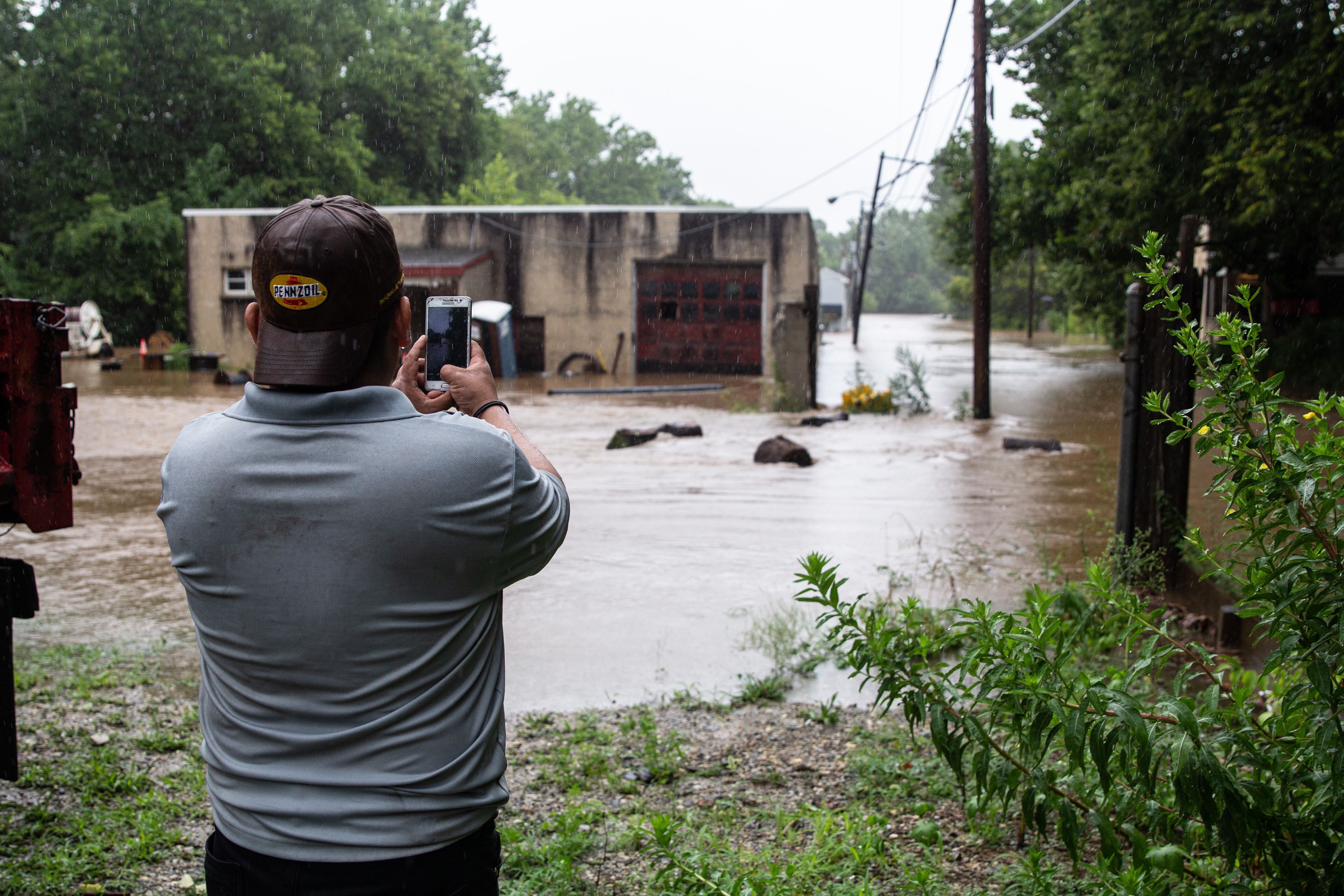
Alfredo Salce works at Paul’s Auto Repair on Colwell Lane. “This morning, we had a call from the fire department that we have to evacuate,” he said. “Pretty much we ran out of there. The water was coming really fast, it was getting flooded really fast.”
Salce said he’s never seen flooding like this before in Conshohocken, and estimated that 5 feet of water was flooding the area near the shop.
In Philadelphia, the city’s Office of Emergency Management advised that all residents should secure loose objects, including trash cans, tents, patio furniture and outdoor signage, due to “sustained high wind gusts.” The city is under a tornado watch until 4 p.m.
The storm made landfall near Ocean Isle Beach, North Carolina, just after 11 p.m. Monday. Originally forecasted as a hurricane with sustained winds of 85 mph, it lost intensity after hitting land and was downgraded to a tropical storm, but its effects are still projected to continue well into Tuesday night. Those effects could be further complicated by the ongoing coronavirus pandemic, since social distancing rules alter evacuation planning and crowded storm shelters’ safety.
The National Hurricane Center reports heavy rainfall and possible flooding along the Mid-Atlantic coast. Tornadoes over Eastern Maryland and the Delmarva peninsula are projected to move northward.
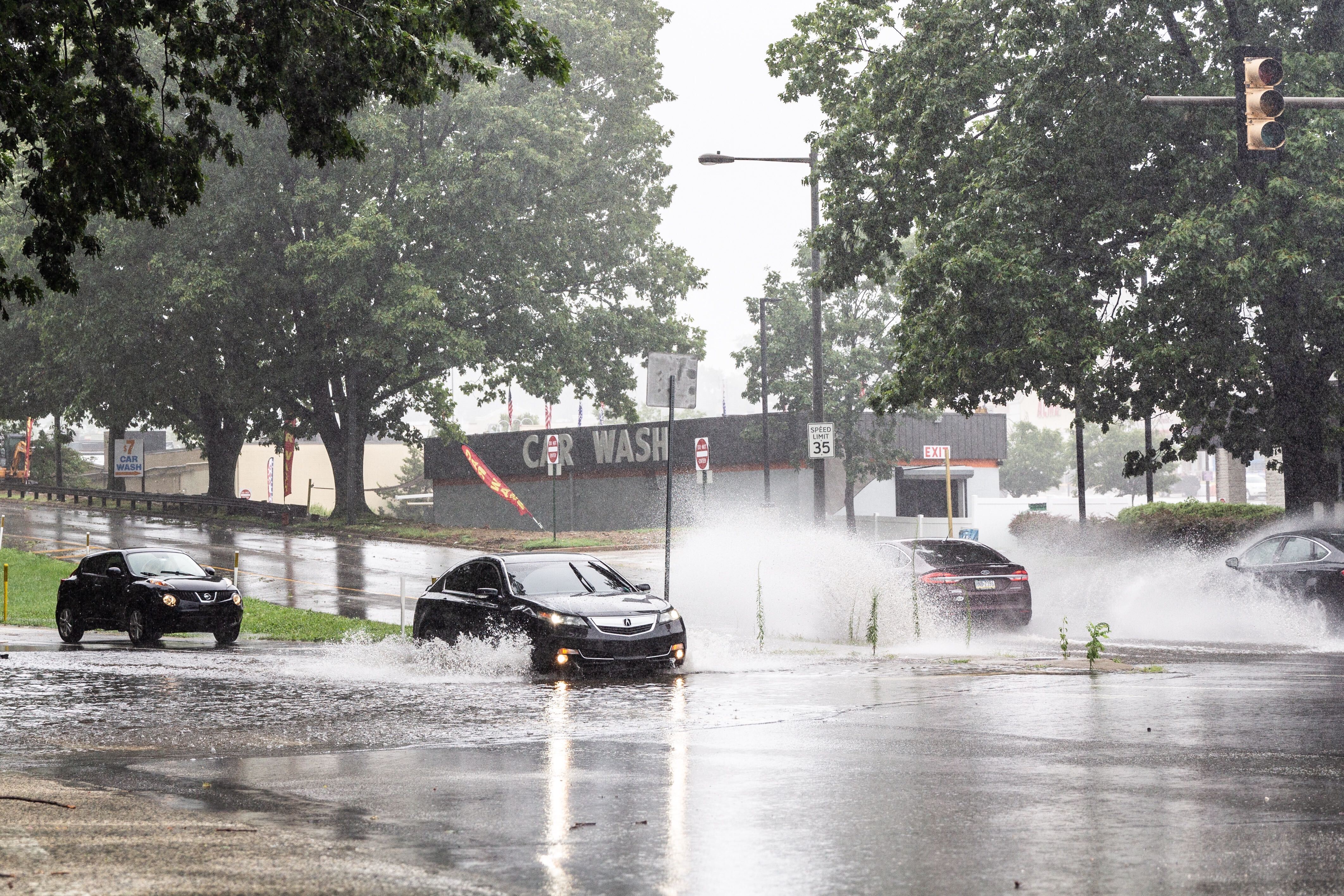
Kimberly Paynter / WHYY
Cars plow through water at Ridge Avenue and Henry Avenue during Isaias’ rains Tuesday.
Street and transportation issues
In Philadelphia, street flooding has closed Kelly Drive between the Art Museum and Falls Bridge, as well as Cobbs Creek Parkway between 70th Street and Baltimore Avenue. Drivers are advised to avoid flooded parkways; as the National Weather Service says, “Turn around, don’t drown.”
SEPTA reported rail delays of up to half an hour due to weather-related problems, with limited service along multiple lines and service to West Trenton and Newark suspended completely. Service on the Norristown High Speed Line has been suspended until further notice due to high water levels. Trolley routes 11,13 and 36 in West Philadelphia aren’t running past 40th Street Station, with shuttle bus service for surface transportation, and trolley routes 101 and 102 are both down.
Centerton Road in Mount Laurel, N.J., was flooded by heavy rain from Tropical Storm Isaias.
Murphy on N.J. storm preparation: ‘We are ready for it’
The entire state of New Jersey was under both a tornado watch and a flash flood watch Tuesday morning as the tropical storm began moving across the Garden State. The state of emergency declared Monday night in anticipation of the storm remained in effect.
Gov. Phil Murphy said residents could see up to five inches of rain in the western parts of the state, 40- to 70-mph wind gusts in some places, and the potential for flash floods in low-lying areas. But he reassured the public that first responders and emergency services personnel were prepared for the coming weather.
“We believe we are ready for it,” Murphy said.
“Hopefully — and this is our best-case scenario — today will be just a washout, and tomorrow we’ll be back to summer sun. But in the meantime, we hope for the best, and prepare for the worst,” he added.
Murphy said the storm was moving quickly and should be out of the area in six to nine hours. State officials urged residents to stay inside if they could, avoid flooded roads and report downed power lines to authorities.
Joseph Fiordaliso, president of the New Jersey Board of Public Utilities, said the state could experience “hundreds of thousands” of power outages due to the expected high winds.
“That possibility exists, and I don’t want anyone to be under the illusion that it does not,” he said.
All state offices were closed Tuesday. Public transit was operating on a normal schedule as of Tuesday morning.
Motorcycles and passenger vehicle-drawn trailers were prohibited on the New Jersey Turnpike and the Garden State Parkway.
A trained weather spotter confirmed a tornado on the ground in the Strathmere section of Upper Township in Cape May County around 9:50 a.m, according to the National Weather Service.
All New Jersey state parks, historic sites, wildlife management areas and natural areas are closed to visitors, the state Division of Fish and Wildlife announced Tuesday morning.
A weather station on Long Beach Island registered a 109-mph wind gust at 10:53 a.m. during a tornadic thunderstorm, according to the National Weather Service. The service said the gust was an outlier and not representative of the tropical storm’s larger wind field.
A nearby weather station in Little Egg Harbor reported a sustained wind of 52 mph and a gust to 70 mph.
Tornado confirmed in Delaware
The National Weather Service has confirmed a tornado touched down in Smyrna, Delaware, along Route 13, and in Dover near Route 8 and Bennington Street.
In Dover, residents took to social media to report snapped power lines and down tree limbs in the area of the tornado.
Delaware Emergency Management also reported damage in Smyrna.
David Marchlik of Middletown said he was at home around 9 a.m. when he heard a roaring sound, and saw massive winds like he’d “never seen before.”
“I shouted to my family, ‘Get downstairs I think we have a tornado going,’” he said.
When the storm passed, the family took a walk in the neighborhood and saw debris and some fallen trees on the pathways. The storm caused significant damage to a neighbor’s house, tearing down the siding, and exposing the second floor of the house on one side.
“We just hope people are okay and getting what they need,” he said.
At a press conference Tuesday, Gov. John Carney said there had been a significant number of power outages, and property damage and flooding. First responders have responded to multiple water rescues, he said.
“Watch the areas where they tend to flood, and don’t venture out to those areas in your car and certainly not by foot,” he said.
Kimberly Paynter / WHYY
Alfredo Salce records footage of the auto shop he works at nearly under water on Colwell Lane in Conshohocken, Pa.
In the Pa. suburbs
A combination of downed trees and high water has closed roads, with reports of trees striking a house in Langhorne and a police car in Bensalem.
Officials in Montgomery County are advising residents under tornado warning to prepare to take cover. That includes getting to an interior room on the lowest floor, staying away from windows, and bringing a cell phone for emergency contact.
“Please stay home if at all possible unless it is an emergency,” Whitemarsh Township tweeted Tuesday afternoon.
WHYY is the leading public media station serving the Philadelphia region, including Delaware, South Jersey and Pennsylvania. This story originally appeared on WHYY.org.
A collection of interviews, photos, and music videos, featuring local musicians who have stopped by the WITF performance studio to share a little discussion and sound. Produced by WITF’s Joe Ulrich.